Blog Categories
- Blog home
- East Central Saskatchewan (2)
- Northern Saskatchewan (4)
- Regina (3)
- Saskatchewan (10)
- Saskatoon (3)
- Southern Saskatchewan (2)
- West Central Saskatchewan (2)
Related Travel Information
The Narrow Hills Adventure Tour
- Author: Trail Guide
- Accommodation: Northern Saskatchewan
My name is Marvin and my wife, Deloris and I own and operate River Trail Country Vacations 15 miles north-north-west of Love, Saskatchewan.
The 1400 square foot cabin was built in 1999 and it was designed to accommodate groups of up to 11 people in modern comfort. All the modern conveniences are supplied including a complete kitchen, three large bedrooms, two full baths, one with a washer and dryer, and all towels and bedding. A complete description of our facility can be found at www.rivertrailcountryvacations.com.
At River Trail Country Vacations we try to provide a variety of interesting pastimes and activities for our guests and one of the more popular of our activities is what we call The Narrow Hills Adventure Tour. This tour starts at River Trail and usually takes 6 to 8 hours to complete, depending on the group and what they would like to see.
The northern half of Saskatchewan holds the vast majority of the province’s (estimated) 100,000 lakes and on this tour we will see quite a few of them.
How It Came To Be
In the late 1920s and early 1930s a trail was developed north of where the village of Love is now located.[1] After crossing the Torch River, [2] the trail followed the river for a few miles before continuing north into the bush, eventually reaching the Fishing Lakes country. The trail was used mostly by trappers, hunters and fishermen until 1937 when it was used by fire fighters trying to control a forest fire that threatened the area.
In 1938 a fire tower, the Narrow Hills Tower, was built at the northern end of this trail and for a while it was provisioned by a Torch River resident, Zac (Jackpine) Anderson, using the trail.
The trail wound its way through virgin forest and generally up hill as it made its way to the top of the glacier produced esker that the natives called Elk Mountain [3] and later came to be called the Narrow Hills. The trail was hilly, crooked, sandy and hard to negotiate by the vehicles that were available in those days. Tractors were often a popular choice of people who traveled the trail and horses were very common on the trail. The trail was so poor that it often took up to three or four days to travel from Love to Lower Fishing Lake and back again, a distance of approximately 60 miles one way. There were some changes made in the trail over the years. Some of the worst hills were bypassed and low (wet) spots in the trail were corduroyed which involved laying logs crossways in the wet spot and covering them with a thin layer of sand.
The trail also had many features that were given graphic and descriptive names by the early travelers. The trail up Stovepipe Hill was crooked and comprised mainly of soft sand. Every vehicle had to be pushed up the hill manually. Shortly after a moderate rain the sand would firm up and travel up the hill would improve greatly. Stovepipe Hill was bypassed many years ago and that section of trail is no longer used.
Potato Hill [4] was another bad one but in later years the trail was clay capped and covered with gravel and it is now quite passable.
A small lake near the trail was called Dead Man Lake for a trapper who drowned in it and whose body wasn’t found until the following spring. All these and more made the trail a very exciting and demanding route to follow.
In the 1950s when I was growing up we made a family trip every year up that trail to get our years supply of fish in a series of three small lakes that were, and still are, called Grace Lakes [5] . We always took three or four 1/2 ton trucks because there was safety in numbers and it took all the manpower we could muster to push the vehicles up some of the hills. We would leave home about 8:00 AM, right after morning chores, and get to the Grace Lakes around sundown, about 12 hours later.
I recall that on one such trip the whole caravan was stopped by a tree. This tree had fallen across the road and there wasn’t a saw or an axe in the whole group. My father was a part-time carpenter and it just so happened that he had a handsaw behind the seat of his truck. It wasn’t a big tree, only six or seven inches in diameter but carpenter’s hand saws were not designed to cut green wood. The problem of drag on the saw blade was partially alleviated by placing a jack near the saw cut and jacking the tree up a few inches. The farther that the saw cut into the tree the more the cut would spread leaving plenty of room for the blade to pass through the cut. In due course the journey was continued.
One of my uncles had a gill net and even though it was illegal for us to use it in the lake it was used anyway, the rationale being that we only did it once a year and none of the Northern Pike that we caught were wasted. Even if we arrived early the net was always set at sundown in the narrows between the middle and third lakes. The reason for setting the net at sundown was simple. In the dark the net could not be seen from the top of the high hill that borders the lakes to the east and, since it was illegal to use a gill net, it was a safety measure. Early the next morning the men went to pull the net and since I was the ripe old age of about seven or so I was often allowed to go. It was usually full of fish and they were taken out and carried up the hill to be processed for transportation home. I remember one time a beaver swam right through the middle of the net so our haul that time was pretty small.
We had to get home as soon as possible because the cows hadn’t been milked the night before or that morning either, for that matter. The return trip was a good deal easier and faster since it is almost all downhill and it only took three or four hours.
By the late 1950s the road had been improved to the point to where it could be traveled in the cars of the day, and even though it was still a little tricky in some places you could make pretty good time.
Nowadays the trip is quite a bit easier and I have made the 40 or so miles from River Trail to Lower Fishing Lake in less than three hours but I must admit that I was in a bit of a hurry.
The tour we will take today is a little more leisurely.
The Narrow Hills Adventure Tour
We leave River Trail Country Vacations at about 9:00AM, traveling in a North-westerly direction along a relatively new road, The Harding Road which was built as a pulpwood haul road in the late 1970s. It is no longer used for that but it suits our purposes very well. As we travel along this road we can still see signs of that long ago fire that played a big part in the expansion of the original trail which, for the most part, we follow. After about a half hour we turn off of The Harding Road and drive down a side road which was also built as a haul road but at a later date. About 15 minutes later we again turn off, down another side road which takes us to a washed out creek crossing. Sometimes we have to add a little fill so we can drive across it and sometimes it is passable, maintained by a trapper who works in that area. Another short drive and we turn onto a bush trail just barely wide enough for the 8 passenger van we are in. Almost immediately we reach the end of the trail. We leave the van and walk down an ATV trail which takes us to a trapper’s cabin on a small lake which is called Beaver House Lake by the locals.
Actually, there are two cabins in the yard. The oldest, built in the late 1930s, is still in pretty good condition though the log walls are starting to show their age. It is about 8 feet by 14 feet by less than 6 feet high with a dirt floor and a sod roof. We can still see the two bunks with the table between that was built by the original trapper many years ago.
About 1964, while on a fishing trip with an uncle, I slept in that old cabin for a night and it was reasonably comfortable. At that time it was still being used by an old trapper named Walter Kraatz [6] who has long since gone to that great trap line in the sky. He probably was the builder of the old cabin since he started trapping in the area in the late 1930s.
The second cabin is a different story.
It was built in the late 1980s and is about 16 x 20 feet x 6 1/2 feet high with a wood floor and walls made of large logs. It has two big double beds, cook stove and lights both operated by propane and a large, wood burning tin heater in the corner, commonly called an air-tight heater. Though I have never spent much time there, I would imagine it would be quite comfortable.
After we inspect the cabins we take a short walk down a scenic bush trail for a look at Beaver House Lake. It is a relatively small lake, about 1/4 mile wide by 3/4 mile long, that got its name by virtue of the 4 or 5 large beaver houses which are located in the lake. The lake was formed by a long, high dam built by the beaver for their safety and also to reach their food supply. I suspect that this lake has been here for hundreds of years as it is easy to see that the dam has been repaired many times.
It is time to continue on our journey so we head back to the van and set off.
After reaching the Harding Road again, we continue down it for another mile or so, finally reaching the Esker Trail, originally called the Fishing Lake Trail by the local people. The true Fishing Lake Trail was located farther west and joined the Esker Trail at its northernmost end. The trail is still, as it has always been, nothing more than two well worn wheel tracks through the forest. In many places it is so narrow that the bushes along the sides of the trail brush both sides of the van as we pass.
It is now after lunch so we are proceeding to a picnic area at a small isolated lake called Falling Horse (now renamed O’Dell) Lake. I have never heard the story of how it got its original name but considering that a quite few of the travelers on the trail used horses, the name was likely suggested by an incident involving one of them.
After reaching the picnic area, we walk down to the lake, a distance of about a quarter mile. The lake, though small as far as lakes go, is a fairly extensive oval with a dent in one side. It is about 1 mile across at its widest point and maybe 2 miles long. The fishing is usually very good because of its isolation and maybe on another day we will try our luck catching a large Pike.
Many years ago, when I was quite a bit younger, I had stopped at this lake to show it to a cousin of mine. We had been fishing at the Grace Lakes and were on our way home with our catch of the day. We had left the fish on stringers in the back of my pick-up while we walked down to the lake. When we got back to the truck we noticed right away that something was amiss. One stringer was hanging over the side of the truck box and the other was missing entirely. A bear had been in the back of the truck, grabbed my stringer with about 8 or 10 Pike on it and went off into the bush. I guess everyone likes a free meal now and again.
Well, now we are hungry so we head back to the van for lunch.
If Deloris is with us we will likely find everything in readiness, the fire going and the hot dogs, potato salad and watermelon all laid out. If I am the chief cook, we all pitch in and very soon the lunch is laid out and ready.
We have to be careful because there are sometimes uninvited guests around. A fellow on one of our tours was sitting at the table and suddenly a Whiskey Jack (Canada Jay) landed on his knee and tried to take his hot dog out of his hand. Failing that, he calmly sat there and proceeded to help himself. The fellow was from Austria and to have a wild animal (or, in this case, a bird) sitting on his knee was one of the most amazing things he had ever experienced. It was the highlight of our lunch break.
Incidentally, the fellow fed his whole hotdog, and more, to the 3 or 4 freeloading birds that showed up for lunch.
It is now approaching 2:00PM and we still have a long way to go.
We load the van and continue on our way.
Except for forest fires the trees have never been disturbed. The northern end of the Esker Trail is in the Narrow Hills Provincial Park [7] and any unauthorized tree cutting is illegal here as it is in all parks. We are traveling through virgin stands of Spruce and Pine, climbing ever higher onto the esker. As we travel we may see moose or deer, and if we’re lucky, maybe even a bear on the trail. Some of the hills we climb are steep, with maybe a small washout or two in them but even so we are steadily getting closer to the most spectacular scene in the area.
Suddenly we reach a well used parking / picnic area. We have reached the lower end of the Grace Lakes. We all disembark from the van and wander around taking in the sights. Not much can be seen of the lakes from our present location due to the huge old spruce trees standing on the hillside so the decision is made to walk down the hill.
If you have a problem climbing steep, high hills it might be best if you wait for our next stop to get a view of the Grace Lakes since the trail down to the lake has a wicked slope. The distance from the parking area to the water is about 200 yards and when I was about 7 or 8 years old I ran all the way up the hill for a nickel, now I couldn’t run a quarter of the way up for $500.00.
As we carefully make our way down the hill we start to see more and more of the lake or actually lakes since, as you may recall, there are 3 of them. When we reach the halfway point we can see a good portion of the 2 larger lakes spreading out to our right. When we reach the bottom we are standing on a small sand beach right on the South-east edge of the middle lake.
I recall that in the mid 1950s I had seen a set of old tire tracks, actually ruts, right down by the lake. One of my uncles told me that a couple of fellows he knew had driven their 4 wheel drive army surplus Jeep down to the lake and had to winch their way back up the hill again due to its extreme slope.
The same cousin who was involved in the bear episode at Falling Horse Lake had driven his Jeep style ’79 Suzuki 4×4 down to the lake in 1980.He just barely made it back up again in low range, 1st gear because of the slope.
In the early 1970s, a small group of friends and I caught over 50 Pike in this series of lakes in a 3 hour period which ended just after sundown. To drag a boat down and then up this very difficult hill, even for such excellent fishing, shows dedication to the sport (and maybe a bit of fanaticism).
Unless you are an excellent swimmer I wouldn’t be too tempted to go for a swim. The lake bottom continues on down at the same angle as the hill above us until it reaches a depth of about 50 feet. The small, shallow lake to the left of us is little more than a beaver pond since it, like most of the lakes in the area, has a large beaver dam at its outlet. The lake we are at is the middle lake and it is a good deal larger and very deep. The last lake in the chain is to our right and is quite shallow, 6 to 8 feet deep with some deeper spots but it is by far the largest of the three in surface area.
It is now time to make our way back up the hill. As we stand there looking up the hill it seems a little daunting but the only way to get it done is do it so we march on. About half way up we stop for a breather even though none of us will admit we need it. We’re doing it for the other guy.
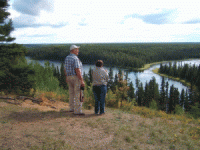
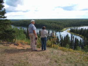
Upon reaching the top we all gather around for a couple of group photos, drag ourselves into the van and continue onward.
The trail, though much improved, still angles steeply upwards for about 1/2 mile and then levels off. We are at the top of the Narrow Hills Esker. [8]
To the west of our vantage point lies a large valley over 10 miles wide covered, for the most part, by virgin pine and spruce. Barely visible in the distance to our left lies Falling Horse (O’Dell) Lake where we had stopped to have our lunch. To our right lies more untouched forest. At our feet lie the sparkling waters of the Grace Lakes. The slope down to the lakes is so steep and high at this point that anyone making their way down to the lakes would have their work cut out for them to make it back up again.
We had one fellow from Germany stand on this hilltop totally enthralled. After about 5 minutes he turned to me and said “I have never seen so much water and no people” (It was fortunate that though I am not fluent in German I speak it well enough to communicate well in that language.)
He was right. In the 5 or so hours that we were on the trail we hadn’t seen one person other than our own group.
The view from where we are now standing has been seen in many photos in a large number of magazines and articles about Saskatchewan scenery and it is truly unique. Our above mentioned web site has some video footage and photos featuring this tour and this scene.
But now it is getting late and we must journey on.
The trail, which continues on north, was built along the very top of the esker until it drops down about 3 miles beyond the Grace Lakes. It is well maintained as the Grace Lakes are a very popular spot for people to come and have a picnic and to take photos of some truly beautiful scenery though overnight camping is not allowed. Along most of these miles we get a good view of the valley to the west. To the east is an even wider valley full of small lakes or kettle holes (9) but it can only be seen at a few points off of a hiking trail built for that purpose.
This is the only trail I know of that divides for traffic heading in opposite directions. At one spot near the north end of the esker, anyone heading north must keep to the right around the bottom of a fairly high knoll while a person traveling south goes directly over the knoll. Both of these trails were the main route at one time. The trail over the knoll was first and the trail around was cut into the hillside in the late ’50s
We soon reach the main road that leads from Lower Fishing Lake to the Narrow Hills Fire Tower. This road is actually the northern end of the original Fishing Lakes Trail. Turning to the right, we are soon at the tower. The trail that we have just traveled was at one time used to provision this tower. The original wooden tower was built in 1938 and manned every summer until about 1950 when a new 90 foot steel structure was erected and some years later a new ranger’s cabin was built.
We stop for pictures and a quick look at the small museum set up in the original ranger’s log cabin and then head back the way we came, passing the Esker Trail on our way to Lower Fishing Lake.
We are soon at Lower Fishing Lake which is a popular summer recreation area with quite a few permanent residents. Some of the year ’round people are employed there and the rest have retired there. They are a very community minded group who are involved in organizations like the Saskatchewan Wildlife Federation, dedicated to improving the lot all living things, both animal and human.
We have one more stop to make about 3 miles down the road. We must stop at Caribou Creek Lodge on Upper Fishing Lake.
The reason we are stopping there is for the Ice Cream. I capitalized those two words because the Ice Cream cones they provide at Caribou Creek deserve recognition. I have never seen ice cream piled so high on a cone in my life and I’ve seen a lot of ice cream cones. Caribou Creek Lodge also has an all season convenience store where they sell gas, groceries, souvenirs and many other items more reminiscent of a general store. There is also a restaurant where the food and coffee are very good. After purchasing a few souvenirs we are ready to head for home.
The trip back to River Trail will probably take about an hour or a little more by the roads we will be traveling. We will be on a paved highway, #106,The Hanson Lake Road (10), for the first 15 or so minutes before turning east on the Harding Road which will take us the rest of the way home.
When we reach River Trail Country Vacations it is time for supper, shower and bed.
It’s Been A Good Day!!!
— Author’s notes —
[1] The village (or more correctly, hamlet) was originally called Love Siding because it was a railroad siding where posts, lumber and other forest products were loaded onto rail cars. There were 2 stories told about how the village got its romantic name.
During Love’s early days it was a mill town having quite a few sawmills within it’s boundaries including a Saskatchewan Timber Board mill and the Johnson Brothers sawmill. The first story goes that a mill worker fell in love with a cook that worked in one of the camp kitchens. Due to this sometimes stormy romance the settlement came to be known as the Siding of Love or Love Siding.
The other story has it that the settlement was named after the conductor on the first train to stop in the town. His last name was Love.
Choose whichever version you like best but bear in mind that the second one is the true story of how the village got its name.
[2] The area that the trail passed through north of the Torch River was surveyed in 1916 but not named until 1932 when the first school district in the region was formed. The school district became known as Torch River SD #4840.
The first settlers to arrive there were Mr. and Mrs. Charlie Otterbein and Charlie Johnson who came to the as yet unnamed Torch River district in 1921. Charlie Johnson stayed in the area all his life but the Otterbeins left soon after.
In 1922 the Otterbeins left the district after Charlie decided that the life of a homesteader / trapper was not for him and became a Timber Cruiser for The Pas Lumber Company east of Carrot River. In 1928 he joined the Dominion Forest Service and then the Saskatchewan Department of Natural Resources in 1931.
In 1924 Jack and Sarah Jardine moved to the former Otterbein property and became the first family with children to settle in that district.
The area we live in, the Moose Run district, SD#5121, is located north and west of the Torch River district and was surveyed in 1931. The trail followed the Torch River which cuts through both districts.
My mother’s family were the first to arrive in our district, the Moose Run district, and they settled 1/2 mile north of our present location after their arrival from Germany by way of Steinbach, Manitoba and Esk, Saskatchewan.(The town of Esk, which was located near Lanigan, Sk, no longer exists) My grandfather, Johann Sager and his step-son, Joseph Kiehn, staked out their homesteads in 1929 and Mr. Sager brought his young and growing family north in 1930, one year before the survey.
Mr. Kiehn brought his wife and infant son north in 1936, after proving up on his homestead. Up until that time he had been commuting between Esk and his Moose Run homestead every spring and fall on his bicycle, a distance approaching 200 miles.
[3] Elk Mountain was the name given to the Narrow Hills Esker by native hunters many years ago. Hunting parties from many areas of the land that came to be called Saskatchewan gathered there to hunt the numerous Elk (Wapiti) that congregated in the valleys alongside the esker. The story is told that during the course of one winter more than 135 Elk were taken in the vicinity of Elk Mountain, hence, its name.
[4] During the forest fire of 1937 there was a camp for the firefighters set up on top of the hill. The cooks at the camp threw their slops over the edge of the hill and some of these slops were potato peeling. Some of these peeling had eyes that took root and grew into potato plants that survived untended on the hillside for a number of years so some of the early travelers on the trail named the hill “Potato Hill”.
[5] The Grace Lakes were named after a lady named Grace O’Drowski who, with her husband and 2 young daughters, lived 1 mile south of us until the mid 1950s. She was the first white woman known to have swum in one of the lakes. The family moved to Prince George, British Columbia in 1955 after Mr. O’Drowski was seriously injured in a logging accident there.
[6] Walter Kraatz, who I knew well, was tower man for the Saskatchewan Department Of Natural Resources (now called Saskatchewan Environment and Resource Management or SERM) at the third Grassy Lake Fire Tower which, at that time, was located just three miles east of the present site of River Trail Country Vacations. He arrived in our area in the late 1930s and took up trapping in the northern forest. He became tower man at Grassy Lake Tower in the early 1940s and retained that position along with trapping in the winter until his retirement in 1965 at the age of 67.He spent his remaining years in Creston, British Columbia, getting married for the first time in his 70s.
About 1971 a new fire tower, also called Grassy Lake Tower, was erected about 5 miles north of that site and the old tower was decommissioned and eventually dismantled
[7] The moving force behind the creation of The Nipawin Provincial Park, now renamed the Narrow Hills Provincial Park was American born Garry Parker. He was the first Field Officer for the new Grassy Lake District of the brand new Saskatchewan Department of Natural Resources and was based at the Grassy Lake Tower site. (Up until December 1st, 1930 the Saskatchewan forest area was administered by the Dominion Forest Service, part of the federal Department Of The Interior) He held that position from 1931 to 1941. His responsibilities were many and included the enforcement of the provincial game laws, providing hunting, fishing and trapping licenses and sending out patrolmen to watch for fires and hand out burning permits to farmers in times of low fire hazard.
Shortly after his appointment as Field Officer, Parker, who had been a federal Forest Ranger up until that time, gave his senior patrolman, Burns Matheson, the task of surveying the area surrounding the Narrow Hills to explore the possibility of creating a provincial park. Using the results of this 2 month survey, Parker pushed for, and achieved, the creation of the 252 square mile Nipawin Provincial Park which was officially established in January, 1934
[8] What is commonly called the Narrow Hills Esker is in fact a “push moraine” which is formed differently than a true esker. An esker is formed when a glacier melts and material that was trapped inside and on the glacier is dropped and washed into a fan shaped series of ridges.
A push moraine is formed by the ploughing effect of an advancing glacier. When the glacier retreats the pushed up material at its leading edge remains, forming a single, long, sometimes curved ridge.
[9] Kettle holes are small, generally round lakes or ponds and it is probable that the ones along the trail were formed by the same glacier that produced the Narrow Hills esker. Kettle holes are formed when ice blocks of various sizes break free from a glacier and are buried in earth and rock debris from the retreating glacier. When the ice blocks melt a corresponding depression is left in the ground. Kettle holes often have no inlet and no real outlet and are filled by seepage, snow melt and summer rain. That may be part of the reason that the beaver dams in these small lakes hold up so well since the only time there is much outflow of water is in the springtime. You will notice that Falling Horse (O’Dell) Lake, the Grace Lakes, the 2 Fishing Lakes and the numerous other lakes and ponds along and near the Narrow Hills trail are of a more or less rounded shape and most are probably kettle holes.
[10] The Hanson Lake Road was named after a Norwegian immigrant named Olaf Hanson. During the 1920s and ’30s he was a trapper and commercial fisherman at Little Bear and Deschambault Lakes. In 1958 he mapped a large portion of the original route of this very popular, paved highway into the Saskatchewan North-East. Road construction was started in 1959 and was completed to Creighton, Saskatchewan in 1962. The road was officially opened in 1964 and paved in 1978.
Hanson eventually went to work as a diamond driller in the mines at Flin Flon, Manitoba until his retirement to Prince Albert, Saskatchewan.
Copyright 2006 by Marvin Torwalt
